Winter 2001
CONTENTS The Measure of the Man
Montana, His Way
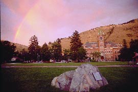
Memorial
A Sense of Space
Sedimental Journey
AROUND THE OVAL
LETTERS TO THE EDITOR
SPORTS
CLASS NOTES
ALUMNI NOTES
Contact Us
About the Montanan
PAST ISSUES
Sedimental Journey Story and Photos by Patia Stephens
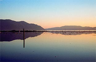
In Missoula, we blithely carry out our lives at the center of what was once geologic ground zero for a cataclysm that shook and shaped the northwestern United States. Some 12,000 years later, the scars of Glacial Lake Missoula remain on the mountains around the University campus. While many people know the Missoula Valley once held an ancient lake, few are aware that Glacial Lake Missoula transformed the terrain from western Montana to the Oregon coast. Helping to tell this phenomenal story is UM geology Professor Dave Alt, author of Glacial Lake Missoula and Its Humongous Floods. The book, a successor to his popular Roadside Geology series, was my guide last summer, when I followed in Alt’s footsteps through the glacial leavings that form a substantial part of the states of Montana, Idaho, Washington and Oregon.
The lake’s brute force tore the once-rounded northern edge of Sentinel down to ragged bedrock as it ripped through Hellgate Canyon. Its beaches left a litany of horizontal lines on the mountainsides of Sentinel and Jumbo. Its receding waters created soggy, vertical mudflow scars on Missoula’s slopes. Buildings, bridges and trees now sprout out of earth that was once, twice, many times under nearly a thousand feet of water. Rocks the size of household furniture decorate campus and neighborhoods across the valley. The very water we drink bubbles up through layers of gravel laid by Glacial Lake Missoula. 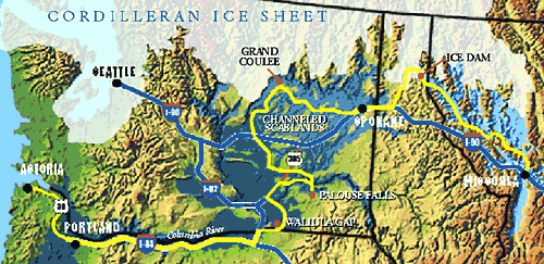 Missoula to the Ninemile Valley At its fullest, Glacial Lake Missoula “held approximately 500 cubic miles of water,” Alt writes, “about half the volume of Lake Michigan. It was, truly, an inland sea.”
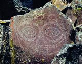
Taking the Ninemile Road exit off Interstate 90, I soon see a large, bleached cliff cut into the road. Here, the lake dropped a load of sediment in which geologists can read a tale of successive fillings, drainings and even seasons by counting “varves” — the light-dark layers left by deposits of pale rock flour, a powder ground by moving glaciers and released in summer meltwater. “Glacial Lake Missoula surely became a splendid and brilliant greenish blue,” Alt writes, “as the last of the summer rock flour settled and the larch trees blazed yellow in the deepening chill of the coming winter.” The record left by the Ninemile roadcut is echoed in sediment deposits all along the flood path, from the Touchet beds in southeastern Washington to Oregon’s Willamette Valley. Surprisingly, none of these sediment dumps has revealed a human presence. Although existing fossil evidence — such as Kennewick Man — postdates the floods, most experts agree that there probably were humans in the Northwest at the time. North to Camas Prairie and Rainbow Lake
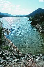
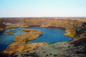
East of Camas Prairie, just inside the western edge of the Flathead Indian Reservation, lies Rainbow Lake, or Dog Lake as it is known locally. An oval basin of glittering water, Rainbow Lake was carved out of black bedrock by an extraordinary current, Alt explains, called a “kolk.” Like an underwater tornado, a kolk drills out chunks of rock and hurls them downstream. Other lakes, such as Flathead, Pend Oreille and Coeur d’Alene, were formed by the slower forces of glacial ice. Alt later explains this astonishing process to me. During the close of the last ice age, he says, lobes of the Cordilleran Ice Sheet slowly receded northward. As they melted, these mountains of ice developed streams and rivers of surface runoff, which carried dirt, gravel and rocks formerly trapped in the ice. This sediment was deposited all around the ice sheet, forming what is now lakeshore. “What’s low was high and vice versa,” Alt says. “It’s a landscape turned inside out.” Another fascinating fact: When they grew, ice sheets pushed mounds of rock and gravel in front of them, creating what are called “moraines.” The hill at the southern end of Flathead Lake, which separates the Flathead and Mission valleys and now is traversed by U.S. Highway 93, is just such a glacial moraine. Downstream to the Ice Dam
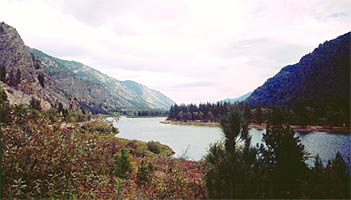
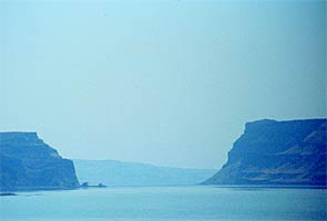
“The peak discharge through Eddy Narrows was approximately ten times the combined flow of all the rivers in the world,” Alt writes. “The drainages of Glacial Lake Missoula were thumping great occasions.” Still, it’s possible for us non-geologists to be blind to the cues around us. I approach the state border alert for the open skyline that signals the trench once traveled by the ice dam. But all I see is mountains and trees and then the silky surface of Lake Pend Oreille. My imagination simply can’t conjure up an ice dam big enough to block the Clark Fork. I return to the area weeks later and slowly the thought dawns on me: I haven’t been thinking big enough. The Purcell Trench lobe of ice spread nearly across the entire Idaho panhandle. The ice dam, merely a small section of the lobe, was three miles long, ten miles across and 2,000 feet tall. When the water behind the dam became deep enough, this southern finger of the vast ice sheet popped up like ice cubes in a glass of lemonade. The breaking ice dam would have let loose a sound to rival a sonic boom. The ground would have trembled like an earthquake as the lake roared onto Rathdrum Prairie south of Sandpoint, Idaho, and then spilled into the much smaller Glacial Lake Columbia, which covered Coeur d’Alene Lake and the Spokane Valley. It would have been like the gunshot start of a race, downhill all the way to the Pacific Ocean. Spokane to Grand Coulee
In 1923, a University of Chicago geology professor named J Harlen Bretz posited an extraordinarily controversial theory: Eastern Washington’s scablands had been formed by torrential floodwaters. At the time, geologic wisdom held that all earth landscapes were formed by slow uniform processes, such as erosion, and never by catastrophic forces. Bretz’s theory earned him the scorn and ridicule of the mainstream geological community. I can almost understand. All my advance reading couldn’t prepare me for the incredible flood features that lay along the highways and back roads ahead of me. I was halfway down Grand Coulee when the size and impact of these floods began to really hit me.
About an hour and a half west of Spokane, Grand Coulee is a broad, approximately thirty-mile-long canyon carved out of the basalt of the upper Columbia River basin. A boater’s paradise of lakes and sleepy resort towns, the coulee is deeply etched into an arid landscape of wheat fields and sagebrush prairie. In the early 1900s, farmers dreamed of irrigating their crops with the river water but had no good way to haul it up the steep canyon walls. With Work Progress Administrative funding, construction began on Grand Coulee Dam in 1933. By the Second World War, the dam was pumping water as well as vast amounts of electricity to the surrounding region.
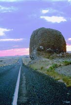
Moses Coulee to Dry Falls Just west of Grand Coulee, things start getting weird. Rocks the size of cars and pickups are strewn about the landscape. These alien boulders are called erratics, and they were deposited by both the Missoula floods and the creeping ice sheet. I’d seen pictures of the biggest alien, an ice-sheet souvenir called Yeager Rock. Driving west toward the small farming community of Mansfield, I round a bend and spontaneously blurt out, “Holy Moly.” Pictures do not do this monster justice. It’s the size of a three-story house, but much more solid. It dwarfs my car and everything else around it.
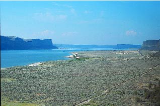
The next stop is Dry Falls, where the Missoula floods gouged a huge hole in the earth. At more than 350 feet tall and three miles across, Dry Falls at its peak was more than five times the width of Niagara Falls, Alt says. The broadly scattered plunge pools below illustrate how the immense floodwaters did not drop vertically like a traditional waterfall, but sloped like an offramp. A small but excellent visitor center at Dry Falls pays homage to Bretz with a dedication plaque that quotes him: “Ideas without precedent are generally looked upon with disfavor and men are shocked if their conceptions of an orderly world are challenged.” Palouse Falls
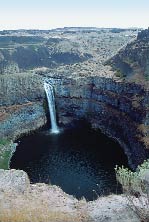
The stream now flowing over Palouse Falls is minuscule next to the plunge pool and canyon below it. These absurdly large features clearly were carved out by much bigger flows, and standing at the edge, I can see how the floods knocked out basalt columns like so many teeth. The floodwaters continued their charge south, following much the same path people take today between Spokane and the Tri-Cities. But where most modern travelers take a shortcut from Kennewick to Hermiston, the Columbia River curves around through a less direct route. The floods took this roundabout, too, only to be stopped short at a narrow space in the hills called Wallula Gap. This dramatic portal created a vast, temporary lake that backed up the flow of the Snake River past Lewiston, Idaho.
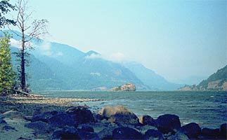
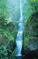
The Columbia Gorge to Portland
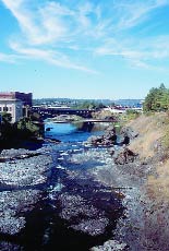
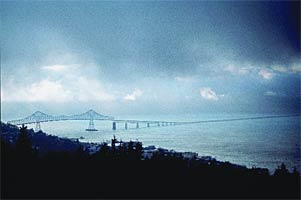
When the wall of water reached Portland, it was a muddy, rumbling mass that would have submerged most of the city’s skyscrapers. Portland’s most notable souvenir of the floods is Lake Oswego, a basin scoured out of basalt rock by the rushing waters. Another flood remnant is the Bellevue Erratic, a sedan-sized rock that rafted in on an iceberg from the Rocky Mountains to just southwest of Portland near Sheridan. As I hiked up the short path to the small state park that surrounds the boulder, I met a man coming down who said, “It’s just odd enough to be worth it.” The rolling farmland around the erratic contains an abundance of vineyards, pear trees and blackberry vines, evidence of the rich topsoil carried downstream from Washington and Idaho. The Final Stretch to Astoria and Beyond
Each time the ice dam broke, the race to the Pacific was over in about two days, a wrecked landscape in its wake. The process repeated every fifty years or so. No one knows exactly how many floods there were, which is only one of many Glacial Lake Missoula mysteries that remain to be unearthed. Geologists disagree on many aspects of the floods, and new discoveries await future scientists. Back in Missoula, some teachers have integrated Glacial Lake Missoula into their curricula. One is UM geography Professor Jeffrey Gritzner, who recently led a busload of twenty-seven Montana K-12 schoolteachers along the floods’ path to Astoria. A summer institute of the UM-based Montana Geographic Alliance, the program explored the geography and history of the Columbia River Basin, focusing on the Missoula floods and the Lewis and Clark expedition, whose paths often overlapped. The teachers went back to their classrooms prepared to share the wealth of knowledge with students.
During my journey west, I noticed a thread of awareness about Glacial Lake Missoula and the floods. They were mentioned at interpretive signs and in visitor centers at Lake Pend Oreille, Grand Coulee Dam, Dry Falls, the Columbia Gorge and the Willamette Valley.
In these challenging times, this is something I can hang on to. If I take any lesson from the incredible story of Glacial Lake Missoula, I hope it is the recognition that in the grand scheme of things, my life and my problems are wonderfully insignificant. Patia Stephens is a writer, editor and Web designer for University Relations. She loves her job because it allows her to indulge her obsessions.

AROUND THE OVAL | SPORTS | CLASS NOTES | ALUMNI NOTES
|