Spring 2001
CONTENTS
Championship Game
Not Your Average Joe
I've Seen Fire and I've Seen Rain
Back Roads Fever
AROUND THE OVAL
LETTERS TO THE EDITOR
BOOKS
SPORTS
CLASS NOTES
ALUMNI NOTES
Contact Us
About the Montanan
PAST ISSUES
by Gary Jahrig
"Ronald Reagan," Running says with a smile. While no great fan of the former president's politics, Running, a UM forestry professor, is quick to give Reagan credit for encouraging NASA to shift its focus from outer space to earth science. "Reagan pushed NASA into pursuing global ecological science," Running says. "He urged them to do more pure science. When you launch rockets for a living, you need to gravitate toward global-scale science that produces real-world benefits."
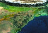
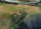
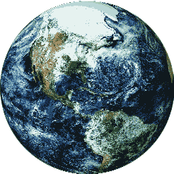
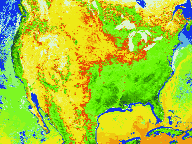
Terra now provides scientists from NASA and around the world the first global and seasonal measurements of the Earth system, including information on land mass and oceans, snow and ice, surface temperature, clouds, water vapor and land cover. Terra also is being used to improve scientists' abilities to detect human impacts on the Earth and its climate; help develop technologies for disaster prediction from wildfires and volcanoes to floods and drought; and start long-term monitoring of global climate and environmental change. A New Take on Earth Science
And that bright light on the Missoula campus has attracted big research dollars from the space agency - more than $10 million since Running first pulled in a $20,000 NASA grant in 1981. "I believe they have brought in more money over the decade of the '90s than any other research group on campus," says UM President George Dennison.
Dennison goes so far as to give Running's group credit for bringing UM into the Internet age. "They were the first ones on campus to require high-speed Internet access," Dennison says. "It became quite clear that we had to figure out a way to get connected." Not only did UM get connected in a technological sense, the Missoula campus is now at the forefront of satellite remote sensing on an international scale. Running's lab has become a clearinghouse for disseminating information gleaned from the satellite data, which is transmitted from Terra to NASA and then to the UM lab.
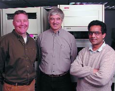
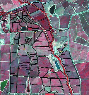
Playing in the Majors The opinions and research of UM scientists Running and fellow researchers Ramakrishna Nemani and LLoyd Queen, are valued highly throughout the world. "We're not a major-league player on many topics," says Running. "We're generally a pretty small player in a pretty small state. We're usually dwarfed by the Stanfords and MITs. But in this topic of scientific global change, we're an acknowledged leader." Nemani is a prime example of what satellite science has done for UM researchers. A native of India, the research associate professor serves as Running's top assistant and is widely recognized as a leading expert in remote-sensing imagery. Nemani, who came to UM in 1983 and was Running's first doctoral student, has earned high praise internationally and locally for his research into global warming and the greenhouse effect. Last year, after studying national warming trends, Nemani turned his attention closer to home and determined that the average annual temperature in Missoula has climbed almost 2 degrees over a fifty-year period. "First I looked at California and Alaska," Nemani says. "Then I decided to look in my own backyard." What Nemani found happening in Missoula, as in other locales affected by warming trends, was rather startling. He determined that the number of frost-free days in Missoula had gone up by fifteen days in a fifty-year period, primarily in the spring. Good news for gardeners, but not so good for skiers. "Two degrees over fifty years may look like no big deal," Nemani says. "But when you dissect it, it can be pretty profound." The NASA connection also has made Nemani a player in the California wine business, a $9 billion a year industry. Nemani and Running are in the midst of a three-year climatic study designed to increase the quality and quantity of wine produced in California vineyards. Using their remote sensing technology, Nemani and the others advise vineyard owners in California's fertile Napa Valley on the best methods to grow grapes. "We found that wine quality is different in various areas of the vineyards," Nemani says. "We found that the best quality comes from plants with fewer leaves. Scrawny plants produce better grapes." Through their research, the UM scientists are able to instruct wine growers on how much water they should use in different vineyards to achieve optimal growing conditions.
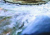
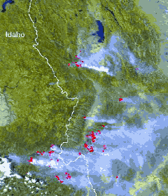
Last summer's devastating wildfires in Montana and other western states also provided a real-world test for the Terra remote-sensing imagery, albeit sooner than many researchers would have liked. "What we were hoping for was to have a few fires over 100 acres in size," says Queen, an associate professor of forestry and a leading expert on using the satellite data as an effective tool in fighting forest fires. "I know it was a goofy thing to wish for, but I thought if we were really going to test how well our model works, we had to have some real-world examples." What Queen and other scientists got by the end of the fire season was a testing field that spanned millions of acres of burnt wild lands. "It was way more than what we wanted and would ever have hoped for," Queen says. "It became clear that what we were doing no longer had anything to do with research. It simply became a point of delivering all the help we could." Queen and others at UM offered their services and technology to fire managers from the U.S. Forest Service and other state and federal agencies. The UM contingent did everything from setting up Web sites for fire information purposes to using the remote-sensing ability to measure the moisture of different forested areas and advising fire managers on how likely certain areas were to burn. "It literally reached a point where people from around the region were asking for our products," Queen says. "We weren't talking about mainlining [their work] for two or three years because we wanted to make sure the models were working properly. But there were unique needs that summer. Fire management teams were looking for all the help they could get." Training & Education Because of the demand for access to the satellite technology by fire managers and others interested in land and resource management, UM has established the EOS Training Center, designed to train land managers in use of satellite data for resource management, and the EOS Education Project, aimed at helping teachers and others understand and apply the earth-science imagery in classrooms and real-world studies. Running's staff provides workshops and other events for land managers in the training center. The EOS Education Project is directed by John Kuglin, a former grade-school teacher now acknowledged as a leading expert in using technology in schools. It has become a model of how university-level science research and K-12 education can team up to improve student learning. (See story on John Kuglin in the Winter 2000-01 Montanan.) The EOS Education Project also has led to UM being selected as the home of the National Lewis and Clark Teacher Education Center. With the bicentennial of the famed explorers' trip through Montana and the West only two years away, Kuglin and a team of educators are using Running's satellite imagery to help teachers supplement their Lewis and Clark lessons. "This will be a resource center available to all those across the country who want to learn from Lewis and Clark's great expedition," Kuglin said at the opening of the new center last spring. "This is a true collaboration between the business community, higher education and government."
Since Terra went into orbit, Running has been a man in great demand. On campus his time is devoted to supervising his lab and a twenty-person staff as well as preparing for the launch of "the next generation of satellites." But he also finds time to teach two classes every fall — a sophomore course on his first love, tree biology, and a graduate class on computer modeling and satellite research. "My continuing to teach in the classroom gives our students a full look at our research activities," Running says. Since the launch, however, Running finds himself spending almost as much time off campus as he does in his lab. "I do a lot of traveling," he says. "But that's what makes this happen. When you are doing global science, you need to build global teamwork." He serves on top-level committees for NASA and travels around the world speaking at conferences and symposiums on earth science issues. The reputation and research of Running and his team are one of the best recruiting tools UM has these days, Dennison says. "What it tells the world is that while we remain a liberal arts institution, we have professors and researchers of science who are of the highest quality," Dennison says. "These are world-class people." Because of his own meteoric rise through the rocket and earth science research ranks, Running also is attracting plenty of attention from other colleges and universities. But Running says it would take a pretty promising offer to lure him away from western Montana, where he has raised a family and enjoys the area's outdoor amenities. "When you get to this stage of your career, other universities don't want to hire you to be a professor. They want you to be a director of an institution," Running says. "The inquiries I get are from universities who want me to come and direct big programs. Well, I'm already directing a big program. "Unless someone can offer a more interesting program in a more interesting place, I'm not likely to just start looking to go moving around," he says. "That would only disrupt my work."
Gary Jahrig '85 is a reporter for the Missoulian.
AROUND THE OVAL• SPORTS • CLASS NOTES • ALUMNI NOTES FEEDBACK•STAFF • ABOUT THE MONTANAN •ARCHIVES HOME • CONTENTS
|
 Steve Running sits back in the desk chair in his fourth-floor office in UM's Science Complex and chuckles when asked to explain how a tree researcher in Montana became one of NASA's foremost rocket scientists.
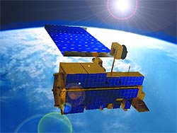
 Today, Running and his team of researchers in UM's Numerical Terradynamic Simulation Group are at the forefront of NASA's efforts to better understand environmental conditions on Earth. NASA plans to spend about $7 billion to launch up to twenty satellites through its Earth Observing System program over the next several years. The first of the spacecraft, the $1.3 billion Terra satellite, was sent skyward in December 1999 from an air force base on the California coast.
 "It's put The University of Montana on the map," he says. "They've been very helpful in that regard. They compete nationally for funding, and that has encouraged others on campus to be competitive. They were there at the beginning when we started to have a huge increase in research dollars."