Winter 2002
CONTENTS
AROUND THE OVAL
CLASS NOTES
ALUMNI NOTES
Contact Us
PAST ISSUES
Alumni Chat
|
Winter 2002 CONTENTS
AROUND THE OVAL Contact Us PAST ISSUES Alumni Chat |
Exploring the ExplorersWhat the Corps of Discovery Can Teach Us Todayby Daniel B. Botkin A few years ago, a group of friends and I canoed part of the White Cliffs stretch of the Missouri River—from Virgelle to Judith Landing. Like many other Lewis and Clark buffs, I had wanted to do this for a long time. I had explored most of Lewis and Clark’s trek across the continent, traveled on the Missouri and Columbia Rivers in other kinds of boats, and traveled on land to this stretch of the Missouri River a number of times. Several times I had come close to getting a canoe in the water when last minute obstacles arose.
So it was with great delight that we put our canoes into the Missouri on a hot August day, pushed out into the current, and started downriver. Lewis and Clark passed that way in June 1805, and we had prepared ourselves to follow their experiences carefully. Among other things, we brought along Gary Moulton’s excellent new edition of the journals. Charlie Beveridge, historian and editor of the papers of Frederick Law Olmsted, America’s great park and landscape planner, was in one of the canoes. He had brought color copies of Karl Bodmer’s paintings of this region of the Missouri River—paintings done in 1834 when Bodmer had accompanied German Prince Maximilian. But more than that, we set out to travel as successfully as Lewis and Clark had done—not merely to endure the Missouri and get out at the end, but to prevail over obstacles and maintain our abilities to think, dream, imagine, conjecture—to continue to function as thinking, civilized people in spite of the challenges of nature—not glumly enduring, but cheerfully prevailing. More than a hundred years before us, Maximilian did what we were doing—retracing the paths of Lewis and Clark—but he did it before color photography and, like any tourist, he wanted color images to remember his trip by. So he brought along his own commissioned painter, Swiss watercolorist Karl Bodmer. Thank goodness he did. Bodmer’s paintings are a beautiful record of what was little recorded—the American West before it was greatly changed by European civilization.
One of our guides pointed out exact geological formations that Bodmer had painted, and at such locations we stopped and compared modern reality with Bodmer’s historical record. In most cases, the scenery of the White Cliffs area had changed little—it was still as fanciful as he had painted it and others had described it—columnar forms like the ruins of some past civilization. Each day the temperature climbed to 100 degrees Fahrenheit. After a several-year drought, the Missouri’s current was slower than usual, but still quite brisk for a major river—about four miles an hour. The water was low and was not working well as an air conditioner. We went about ten miles or so each day and felt exhausted by the time we had pulled our canoes ashore and put up our tents. Wow, what a day’s work, we said. Then we took out the Lewis and Clark journals and looked to see how far they had gone in that same location. Each day we discovered that the Corps of Discovery had gone considerably farther upstream than we had gone downstream. It was a sobering thought. I knew that Lewis and Clark and the men who went with them were strong, but knowing and feeling it were quite different, and each day we really felt it. The more our muscles ached, the more our respect grew for that group that passed this way in 1805 and returned in 1806. It is easy for an armchair explorer to romanticize what Lewis and Clark did, and believe that they were probably just like us, not only in physical prowess, but also in the way they looked at the world—including how they looked at nature and themselves. If we think we would be tired out, we assume they would be, too. If we think we would be frightened, we assume they would be, too. If we believe something about nature, we assume they believed it, too.
But that’s wrong. And we can learn much from the Corps of Discovery: about how people thought, felt, and acted toward nature almost two hundred years before us; what the American West was like before it was changed by European civilization; and how they were able to succeed in their travels despite notable challenges. Their success continues to amaze us: They lost only one man, who died of appendicitis, unrelated to the expedition’s experiences; they made it to the Pacific and back as a small party of thirty-three, including Sacagawea and her baby boy; and not only were vigorous during the day, but had enough energy at night to make detailed entries in their journals, some of the best natural history journals of any expedition in human history. They had to be smart and practical. They also had to understand and accept nature for what she really was, and deal with whatever she wanted to give out. And give out tough situations she did. When Lewis and Clark reached the great falls on the Missouri River, a little way upstream from where we were struggling to canoe downstream, nature let go with a whopper of a hailstorm. For once, Lewis and Clark had taken time off to do a little sightseeing. The Indians had told them about a giant spring just above the falls, and they were out to see it. They found it and were impressed. “This water boils up from under the rocks near the edge of the river and falls imediately into the river 8 feet and keeps its Colour for a mile which is emencely Clear and of a bluish Cast,” Clark wrote with his own style of spelling, appreciating the spring as much as any modern tourist, but going a step further by taking measurements and describing the area carefully. Like Clark, Lewis takes measurements, writing that the spring was about 25 yards from the river, “situated in a pretty little level plain, and has a suddon decent of about 6 feet in one part of it’s course.” A difference between Lewis and Clark and we modern travelers is their penchant for quantitative measurements, important to modern scientific use of their journals. On his way to the giant springs, Lewis was “overtaken by a violent gust of wind and rain from the S. W. attended with thunder and Litning.” He took shelter “in a little gully wher there were some broad stones” that he thought he could use to protect his head from hail. He remained for about an hour “without shelter and took a copious drenching.” Clark, meanwhile, was ascending alongside the series of falls so that he could retake some notes about the river that he had lost on his previous ascent. With him was Charbonneau, the French-Canadian interpreter, his Indian wife, Sacagawea, their baby boy, Pompey, and York, Clark’s manservant. They too saw the black cloud coming. Clark “looked about for a shelter but could see no place without being in great danger of being blown into the river if the wind should prove as turbelant as it is on some time ....” He found a deep ravine with “shelveing rocks” where they took shelter. He put his guns and compass under one rock. “Soon after a torrent of rain and hail fell more violent than ever I saw before,” Clark wrote. Mother Nature was at it. The intensity was so great that it produced a flow of water into the ravine where he and Sacagawea had taken shelter. It was clear that they had to get out of the ravine. Clark took his gun in his left hand and used his right to help Sacagawea, who was carrying her baby. “Before I got out of the bottom of the revein,” Clark wrote, ”the water was up to my waste & wet my watch.” By the time he reached the top of the ravine, he estimated that the water had risen at least 15 feet (once again, nothing stopped him from making quantitative observations). Sacagawea’s baby had lost his clothes, she herself was wet and cold and “just recovering from a Severe indisposition.” Other members of the expedition also suffered from that storm. One was “nocked down three times and others without hats or any thing on their head bloody & complained verry much,” Clark wrote. He gave everybody a little grog, he added. Great! I thought, sipping a martini at our campsite and reading the journals. I’m sure that made the guys feel much better. That night at our campsite the wind picked up and blew with violent gusts through our tents, so that I had to venture out and check that everything was holding down. Some of our party said in the morning that they had never experienced anything so violent, and they were afraid in the night. I imagined Captain Clark passing them a little grog and telling them to get back to work—canoeing upstream. In the midst of Clark’s escape from the rising water, he had lost the expedition’s large and best compass, which was a “serious loss,” he wrote. Huh. We had compasses on our trip, but after all, we only had to follow the river, so the loss of a compass would have mattered little to us.
Fortunately for Lewis and Clark, the next morning two of the men went to the falls and found the compass covered with mud and sand, but everything else, including a tomahawk, shot pouch, powder and balls, moccasins, and the baby’s clothes and bedding, were gone. In the morning after our storm, a few of my things had gotten wet, but nothing that I did not have a second set of. The abilities of Lewis and Clark went considerably beyond strength, courage, endurance, and measurement. They also had to battle against some of the beliefs and ideas that had engendered their expedition. When they set out from St. Louis, the prevailing belief among geographers, natural scientists, and other intellectuals, including Thomas Jefferson, was that the best route to the West would be up the Missouri to its headwaters, across the mountains, and then down the Columbia. Their reasoning was governed by the ancient but still accepted myth of the balance of nature, one of whose precepts, tracing back to the Greeks, was that nature was—and had to be—symmetric. This meant that North America had to be symmetric—the mountains of the West had to be exactly like those of the East; a crossing of the Rocky Mountains would be an easy one- or two-day event. One expert cartographer of the time wrote that the mountains could be no more than 6,320 feet high. How exact! But how wrong. Nature in the American West was anything but a simple, elegant balance, as anyone surviving that hailstorm at the great falls ought to realize. Lewis and Clark realized this, accepted it, and dealt with it. If they had not, they probably would have died along the way. One of their most impressive experiences in dealing with nature-as-it-really-was took place when they reached the confluence of the Marias and Missouri Rivers. On June 3, 1805, the expedition was camped at what we now know as the mouth of the Marias River, but which appeared to Lewis and Clark as the junction of two large rivers. The problem was that they weren’t sure which of the rivers was the Missouri—the river that flowed in from the north, or the one that flowed in from the west. In a certain sense this is arbitrary, because at the confluence of two major waterways, you can call either one the upstream continuation of the main river. But for Lewis and Clark, the question was: Which river would take them the farthest into the mountains and give them the best route over the Rockies to the Columbia? The Indians had told them to search for a river that had some great falls on it. This would lead them to the trails used by the Indians to pass over the mountains. Choosing the wrong river and following it would have serious consequences for the expedition. “To mistake the stream at this period of the season, two months of the traveling season having now elapsed, and to ascend such stream to the rocky Mountain or perhaps much further before we could inform ourselves whether it did approach the Columbia or not, and then be obliged to return and take the other stream would not only loose us the whole of this season but would probably so dishearten the party that it might defeat the expedition altogether,” Lewis wrote. Great! I thought, still sitting at my campsite. Finally something has daunted old Meriwether. But not for long. Although the future of the expedition, perhaps even their lives, depended on the right choice, Lewis took a detached, almost scientific approach, as if he were a modern scientist sitting in a comfortable laboratory office, rather than at a rough camp in bad weather. I imagined how one of our crew would have reacted to this situation. Probably it would have taken another round of grog. Lewis calmly proposed an experiment: “To this end an investigation of both streams was the first thing to be done.” He recognized the need to measure things about the river, making observations quantitative, to “learn their widths, depths, comparative rapidity . . . and thence the comparative bodies of water furnished by each,” and by these means attempt to infer which was the Missouri. Most of the men believed the north fork was the river to follow. Its waters ran “in the same boiling and rolling manner which has uniformly characterized the Missouri throughout its whole course . . . .” On the other side were Lewis and Clark who, Lewis wrote, were “not quite so precipitate.”
They decided to explore both forks, what scientists would call testing the two hypotheses. The next morning Clark led a group up the west fork, while Lewis took a group up the north. The rest of the expedition remained at the base camp where the two forks joined. Lewis traveled up the north fork for two days. He found that this fork continued northward toward what is now the border between Montana and Alberta, Canada, and he became convinced that this direction was too far to the north to be the route to the Pacific. Lewis returned, discussed the situation with Clark, and the two agreed that the west fork was the right one. The rest of the crew, still skeptical but with great faith in the leaders, acquiesced. Lewis and Clark were correct; they got to the mountains and over them just in time, finding them much more challenging than 6,320-foot-high mountains of the east. Throughout their travels, Lewis and Clark made use of what we call today the elements of the scientific method. First, they measured and counted just about everything. Each time they saw grizzlies, they wrote down how many (usually one), where, and when. From those counts, I was able to get a rough estimate of the original number of the grizzlies, a number available no other way. They observed carefully and objectively—from determining how big a pelican’s beak was by pouring known quantities of water into the beak of one that had been shot, to examining the shore of the river as they traveled up it to see where would be the best locations for towns. From their observations, questions arose about the causes of what they saw, and they wrote down conjectures—once again, scientific hypotheses—to explain what they saw. And they were often right. Clark saw a good harbor near the present location of Kansas City. It was aside an island, and he wrote that the harbor formed because the island forced the water to speed as it flowed around it, eroding the outside of the curve and cutting a natural harbor. He understood, therefore, what we call hydrodynamics. As our group approached our takeout point at Judith Landing, I realized that for most of our journey downstream we had been too occupied with the work of travel and with our own conversations to have the time to measure, count, or do very much in the way of scientific conjectures. We hauled our canoes out just at lunch time, set out paper plates and cups, and got ready to sit down to a pleasant meal. Suddenly, under a clear sky, a strong wind arose, scattering our paper plates and cups and tossing food on the ground. Once we collected all that we could, we went down to the shore as the wind grew stronger. Several canoeists from another group were struggling to make it to the takeout point before the wind flipped their canoes. They edged slowly along the shore, sometimes reaching out to a branch to steady their crafts, sometimes using a curve to get a little more out of the wind. We walked upstream as far as the cottonwoods along the shore allowed and grabbed their ropes, pulled them down to the landing and got them safely ashore, just as our canoes, which had been laid upside down but left untied, began to blow away, so strong was the wind. We scrambled in a wind forceful enough to almost push us to the ground and managed to tie our canoes with bungee cords to various objects. It was as near as we had come to experiencing the violence of the Missouri River environment as Lewis and Clark had become accustomed to. This ending to our adventure brought us closer to theirs than we had expected, and closer than we probably wanted. It set us to thinking once again about what great explorers they were. When we study Lewis and Clark and their voyage of discovery, we find much more than a simple adventure. We find that Lewis and Clark were tough, courageous, and devoted to quantitative observations, which they recorded carefully. They were able to overcome the limitations of their cultural heritage and use the equivalent of the scientific method under the most difficult circumstances. They did not simply endure the American West from within their own culture; they prevailed because of their abilities, physical and intellectual, to break out of a mold.
|
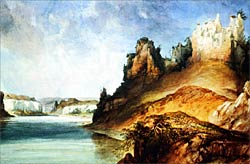 View of the Stone Walls by Karl Bodmer
Courtesy of the Joslyn Art Museum, Omaha, Nebraska
Gift of Enron Art Foundation
View of the Stone Walls by Karl Bodmer
Courtesy of the Joslyn Art Museum, Omaha, Nebraska
Gift of Enron Art Foundation
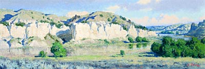 Morning Light on the White Cliffs, by Charles Fritz, 2001, oil on canvas, 10 x 28.This painting is part of a national touring exhibit of Lewis & Clark sites by Charles Fritz, coordinated by the Montana Museum of Art and Culture at UM-Missoula.
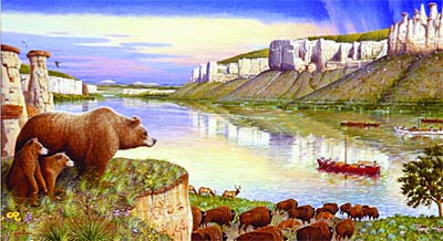 Lewis and Clark & the Corps of Discovery, ©2001 by Monte Dolack, commissioned by the Lewis & Clark Interpretive Center in Great Falls.
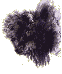 Head of a Buffalo by Karl Bodmer
Courtesy of the Joslyn Art Museum, Omaha, Nebraska
Gift of Enron Art Foundation
Head of a Buffalo by Karl Bodmer
Courtesy of the Joslyn Art Museum, Omaha, Nebraska
Gift of Enron Art Foundation